Welcome
Welcome to Open House #1
Elgin Mills Road / CN Railway Crossing (Yonge Street to East of Newkirk Road) | City of Richmond Hill
Welcome to the first Open House for the Elgin Mills Road / CN Railway Crossing Environmental Assessment (EA) Study. The commenting period for Open House#1 is from January 27 to February 17, 2022.

Purpose of Open House #1
Introduce the Project
Share key feedback received so far
Summarize the Region’s 2016 TMP recommendations for the corridor
Present the study findings to-date
Introduce Alternative Design Concepts to be developed in the next phase of the study
Obtain your input about the project
Privacy Statement:
Please note your personal information (e.g. name, address, and phone
number) is collected, maintained, and disclosed under the authority of
the Environmental Assessment Act and the Municipal Freedom of
Information and Protection of Privacy Act for transparency and
consultation purposes.
Personal information submitted will become part of a public record that
is available to the general public unless it is requested that the
personal information remain confidential.
How to Navigate
- Click on the arrows at the bottom of your screen
- Use the navigation bar on the left of your screen to revisit any part of the Open House slides or to skip to a slide of interest to you
- Click the “Audio” button at the top right corner of the page to play audio for each slide
How to Participate
- Click on the arrow at the bottom of your screen to get started and learn about the project. Some slides have areas to leave feedback on the information presented. Enter your feedback and press SUBMIT to send your comments to the project team
- You can also email your comments to the project team at Jackson.Marin@york.ca
Contact Information
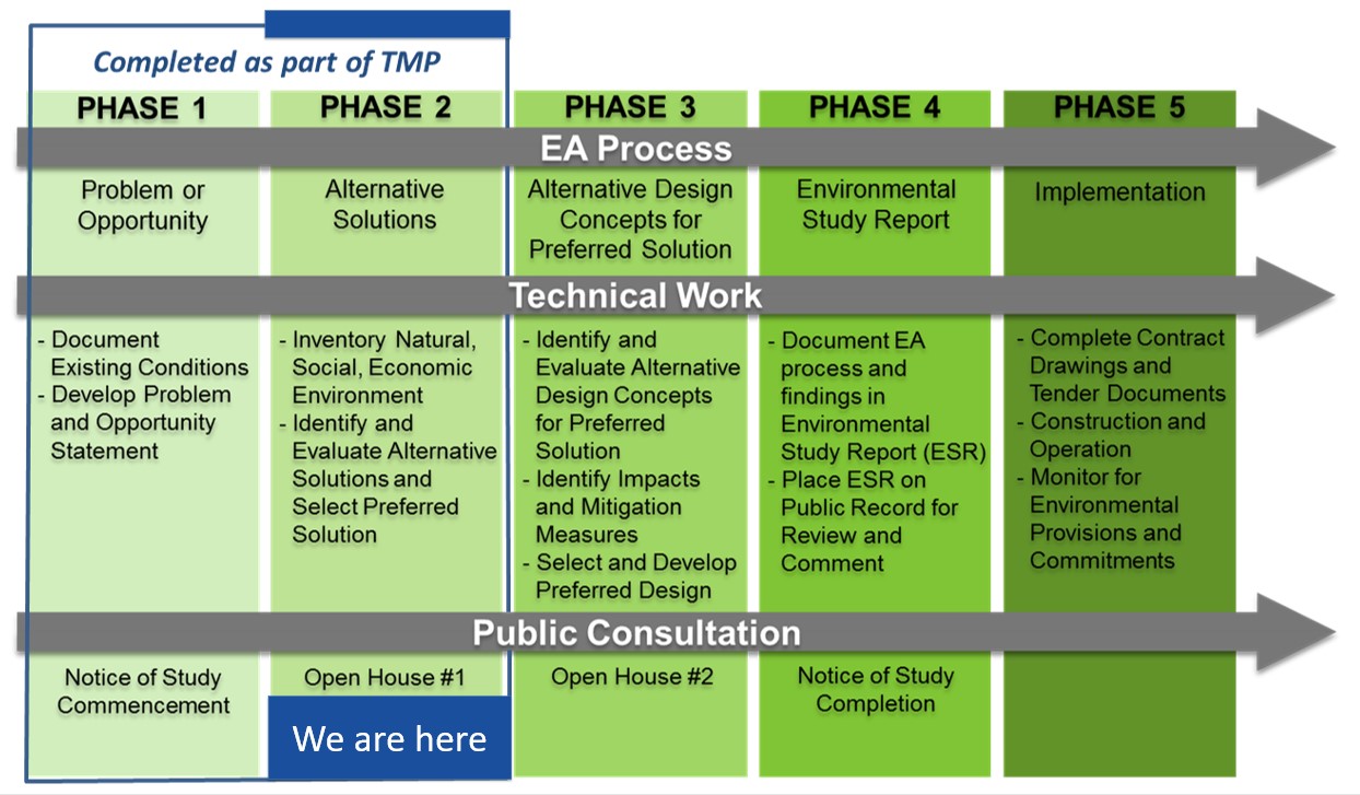
EA Process and Study Objectives
Project Description
York Region is undertaking a transportation Environmental Assessment (EA) Study for improvements to Elgin Mills Road between Yonge Street and East of Newkirk Road, in the City of Richmond Hill.

Environmental Assessment (EA) Process
An Environmental Assessment (EA) is a planning and approval process for municipal infrastructure projects, legislated by the Ontario Environmental Assessment Act. This EA study is being conducted as a Schedule ‘C’ project under the Municipal Class EA document (October 2000, as amended in 2007, 2011, and 2015). This EA study incorporates the Transportation Master Plan (TMP) process.
Study Objectives
 To accommodate current and future
transportation needs for all modes
(pedestrians, cyclists, transit users
and motorists)
To accommodate current and future
transportation needs for all modes
(pedestrians, cyclists, transit users
and motorists)
 To supplement the findings of the
2016 York Region Transportation
Master Plan (YR TMP)
To supplement the findings of the
2016 York Region Transportation
Master Plan (YR TMP)
Study Area Features
The EA study area is along Elgin Mills Road between Yonge Street and East of Newkirk Road, in the City of Richmond Hill.
Key features of the corridor include:
German Mills Creek Crossing
Yonge Street Rapidway
Sidewalks on both sides, no cycling facilities
CN Railway / Richmond Hill GO Rail Crossing
Residential, Commercial and Industrial land use adjacent to Elgin Mills Road
Four Lane Urban Arterial
Road
60km/h posted speed
Traffic Signals at Yonge Street, Yorkland Street/ Enford Road, and Newkirk Road intersections
Community Outreach
Community Outreach and What We’ve heard
Community Outreach
 Direct Mail Notices

 Technical Review Agencies
 Newspaper Notices
 York Region Social Media
 Online Survey
 Open Houses
 Stakeholders
What We’ve Heard
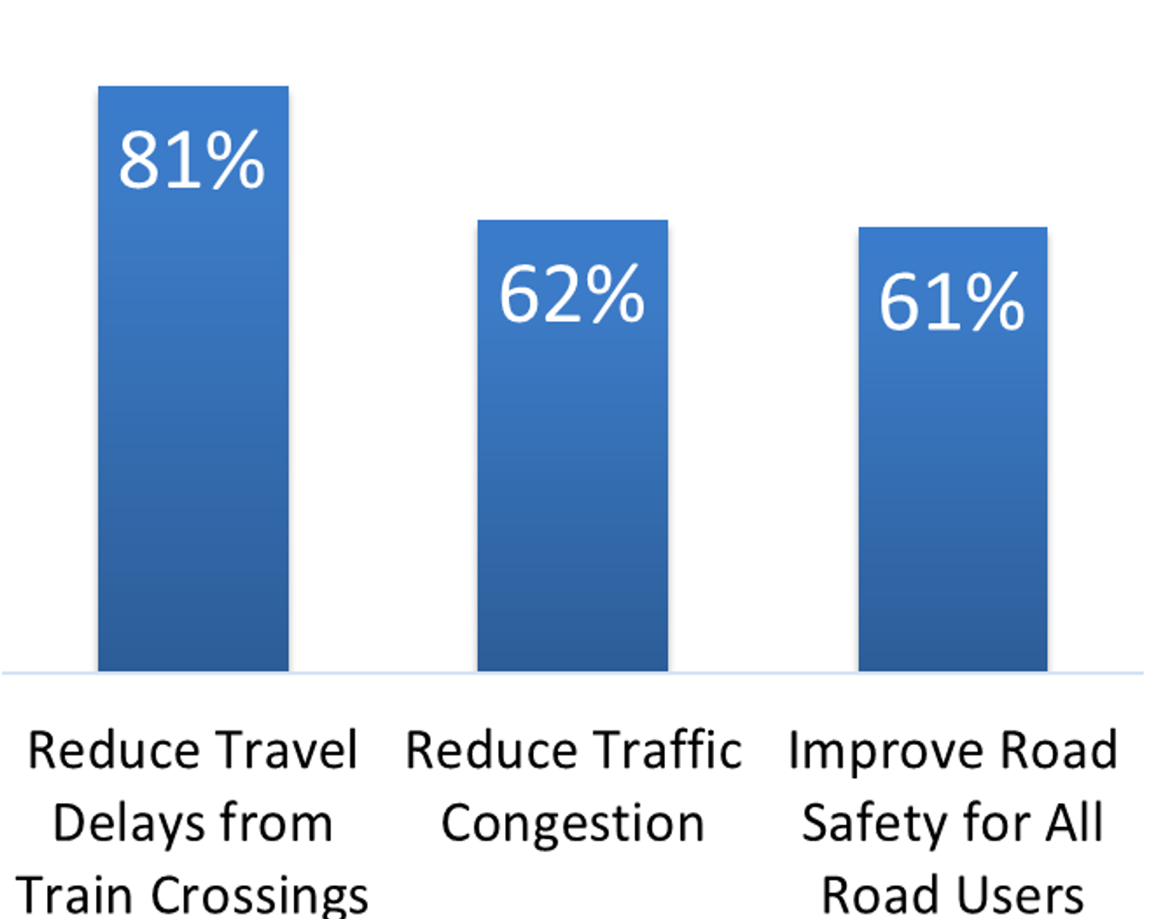
Online Survey Results
Based on 222 survey responses collected between November and December 2021:
Your top 3 concerns along Elgin Mills Road:
Percentage of respondents indicating concern as “very important”
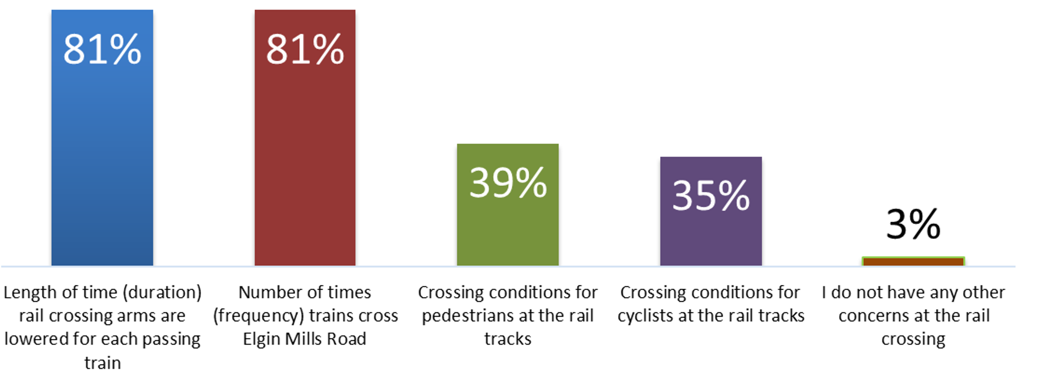
Your top concerns at the Railway Crossing:
Percentage of respondents identifying the concern.
Your most important features along Elgin Mills Road:
Percentage of respondents selecting features that are important to them.

Your top 3 factors to make WALKING more attractive along Elgin Mills Road:
Pedestrians do not cross at the same level as the train tracks (Elgin Mills Road raised / lowered)
Increased separation from moving vehicular traffic
More attractive, comfortable streetscape (e.g. more street trees, landscaping, amenities such as benches and public art)
Your top 3 factors to make CYCLING more attractive along Elgin Mills Road:
Cyclists do not cross at the same level as the train tracks (Elgin Mills Road raised / lowered)
New paths (in boulevards) for cyclists, separated from walking
I would not cycle along Elgin Mills Road
Your top 3 factors to make TRANSIT more attractive along Elgin Mills Road:
Efficient transit routes
On-time transit service
Transit routes with connections to GO Train stations / services
General Comments:

Concerns with the maintenance at the rail crossing (bumpy travel for vehicles crossing the tracks)

Delays to Emergency Vehicles while trains are passing

Noise concerns

Strong support to construct either an overpass or underpass and build it soon. Request to leave the crossing at-grade as improvements aren’t needed

Increased development and population growth will contribute to existing congestion

Construction of an overpass / underpass will be costly and take a long time to complete.
We want to hear from you
Planned Growth, Part 1
Planned Growth and Planning Policy Context
Planned Growth
York Region is forecasting significant growth. Infrastructure improvements are needed to support this growth. This EA study reviews opportunities for infrastructure improvements along Elgin Mills Road between Yonge Street and East of Newkirk Road.


Planning Policy Context
To establish the vision for the Elgin Mills Road corridor the project team completed a review of relevant planning documents and background studies including but not limited to:
Municipal
- Richmond Hill Official Plan
- Transportation Master Plan Update
- Pedestrian and Cycling Master Plan
- Richmond Hill Railway Crossing Grade Separation Prioritization Study
Regional
- Regional Official Plan
- York Region Strategic Plan (Vision 2051)
- Regional Transportation Master Plan
- York Region’s Sustainability Strategy
- York Region’s Pedestrians and Cycling Master Plan
- York Region’s Pedestrian and Cycling Planning Design Guidelines
- York Region’s Transit Annual Service Plan
- York Region’s Roads and Transit Capital Construction Program
Provincial
- Provincial Policy Statement, 2020
- A Place to Grow (Growth Plan for GGH)
- 2041 Regional Transportation Plan (Metrolinx)
- Ontario’s Climate Change Action Plan
- Greenbelt Plan
- Oak Ridges Moraine Conservation Plan
Key findings from the document review include:
Richmond Hill Railway Crossing Grade Separation Prioritization Study (2016)
The Elgin Mills Road crossing of the CN Railway corridor east of Yonge Street was identified as the highest priority crossing requiring a grade separation of the seven road /rail crossings studied in the City of Richmond Hill
YR Official Plan
Designates a 36.0m official plan right-of-way for improvements to Elgin Mills Road
Planned Growth, Part 2
Planned Growth and Planning Policy Context, continued
YR Transportation Master Plan (TMP) Study (2016)
Development of a Road Network Fit for the Future (2041) , YR TMP 2016 Map 8
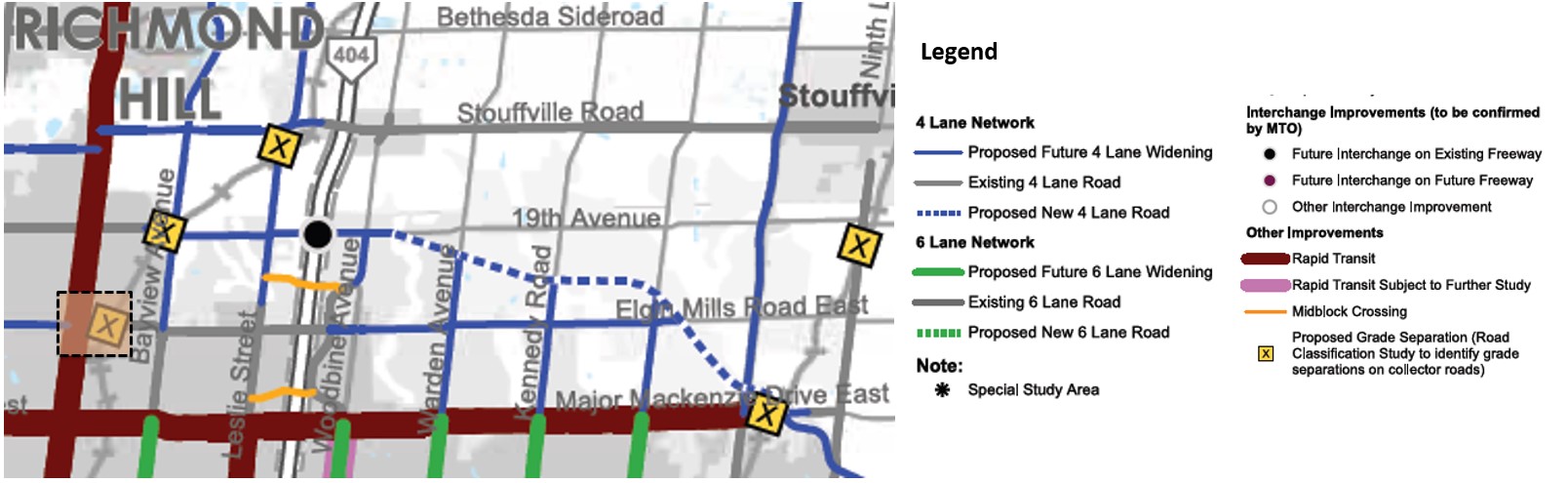
Four lanes for Elgin Mills Road and the need for a Proposed Grade Separation at the CN Rail Crossing

Supporting the Frequent Transit Network (2041) ,YR TMP 2016 Map 7
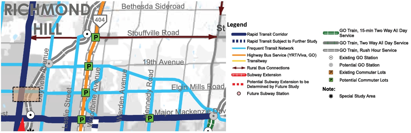
Elgin Mills Road as part of the Frequent Transit Network
Growing the Cycling Network (2041), YR TMP 2016 Map 9
Separated active transportation facilities for pedestrians and cyclists along Elgin Mills Road
Summary of TMP Recommendations
Summary of TMP Recommendations for Elgin Mills Road
The York Region TMP (2016) completed Phases 1 and 2 of the EA process and identified the Preferred Solution for improvements to Elgin Mills Road.
TMP Phase 1: Problem and Opportunity Statement
Identified the Needs and Justification to define the Problem and Opportunity Statement for improvements to the Elgin Mills Road corridor
 Identified the
Network improvements for the Elgin Mills Road corridor are needed to:
- Address existing congestion and future travel demands
- Support walking, cycling, and transit along the corridor
- Improve pedestrian and cyclist safety at the crossing and reduce delays to transit and traffic along the corridor

TMP Phase 2: Alternative Solutions
Developed and Evaluated Alternative Solutions to address the P&O Statement
 Developed
and Evaluated
Developed
and Evaluated - “Do Nothing”
- Improve Grade Crossing Safety
- Transportation Improvements To Adjacent / Parallel Corridor
- Construct Rail Grade Separation
Structure
-
Recommended because:
- Traffic and train volumes are expected to exceed exposure warrants for grade separation
- Grade separation improves pedestrian and cyclist safety
- Reduces delay to transit and traffic along the corridor
 Construct Rail Grade Separation
Structure
Construct Rail Grade Separation
StructureTMP Preferred Solution
Selected a Preferred Solution for the Elgin Mills Road corridor
 Selected
a
Selected
a The Preferred Solution for Elgin Mills Road was identified as Construct Rail Grade Separation Structure due to its alignment with the five YR TMP objectives (support transit, support road network, support active transportation, support goods movement, and supports last mile).
Transportation Conditions, Part 1
Reconfirming the Preferred Solution
Transportation Conditions
To reconfirm the recommendations and TMP Preferred Solution, the EA project team completed an updated Transportation Assessment and assessed the existing and future conditions for Elgin Mills Road. The following highlights the key findings.
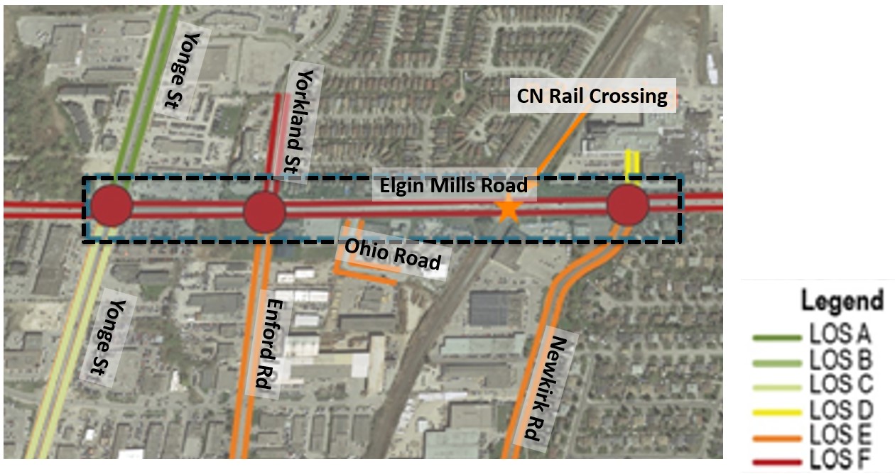
Traffic Operations
Existing Traffic Conditions
Elgin Mills Road
- Operates within capacity with localized congestion points experiencing longer delays
- Vehicle queues from train crossings extend to and impact intersection operations (Yorkland Street and Newkirk Road) and driveways
- Vehicle queues extend to the railway crossing from Newkirk Road intersection during the morning peak
Future 2041 Traffic Conditions
- Elgin Mills Road capacity will improve with a grade separation, but still experience congestion. Anticipated vehicular demand in the area should be monitored in the future
- Separating Elgin Mills Road at the railway crossing (grade
separation) is forecasted to:
- Increase throughput along Elgin Mills Road
- Reduce delays at the rail crossing
- Reduce vehicle queue spillbacks from the railway crossing to adjacent intersections
Grade Separation Exposure Index
An exposure index is used to determine whether a grade separation should be considered based on traffic volumes, and the number of trains at the crossing each day. Grade separation is considered when the exposure index exceeds 1,000,000.
At the Elgin Mills Road crossing of the CN rail, in future conditions (2041) the exposure index is anticipated to be >1, 698,000.
The grade separation exposure index is exceeded.

Source: Google Maps
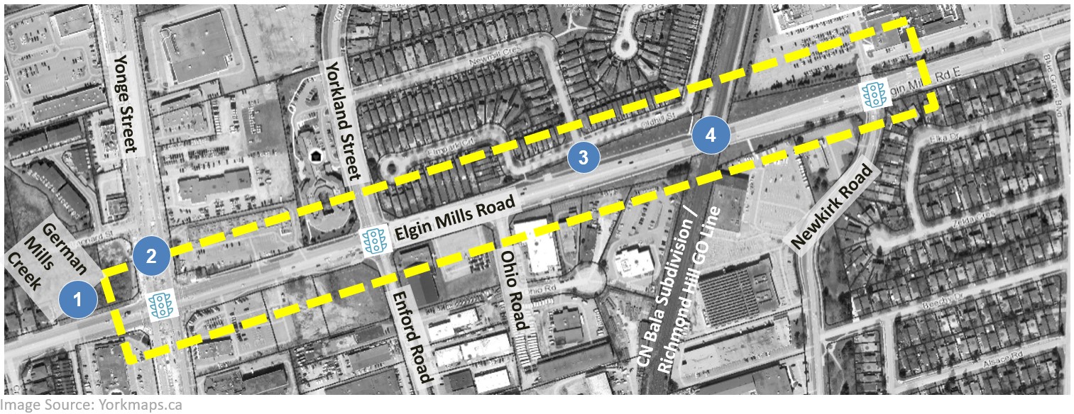
Existing Rail Crossing Conditions
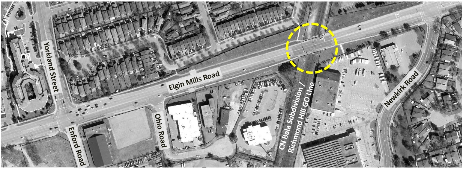
Image Source: Yorkmaps.ca
Rail corridor is currently serviced by CN Freight Rail, CN Corridor Maintenance, GO Commuter Rail and VIA Commuter Rail
Vehicles are delayed at the crossing as they are required to stop for trains to cross – safety concerns for motorists due to conflicts with crossing trains
Increased train frequency is forecasted. Lengthy duration of train crossings (e.g. freight trains)
Vehicle queues extend to adjacent intersections when crossing arms are lowered for passing trains
Safety concerns for pedestrians at the existing CN Railway crossing
Elgin Mills Road does not support cycling facilities at the CN Railway crossing
Transportation Conditions, Part 2
Reconfirming the Preferred Solution
Transportation Conditions, continued
Pedestrians
- Sidewalks are found along the north and south boulevards of Elgin Mills Road
- Pedestrian connections / pathways to residential and commercial / industrial lands are present northwest and southeast of the rail crossing
- Pedestrians cross many lanes at signalized intersections
- Pedestrians cross the rail tracks at a level crossing

Cyclists
- There are no existing cyclist facilities along Elgin Mills Road. Cyclists travel in mixed traffic
- Cyclist cross the rail tracks at a level crossing
Transit
- Route 80 Elgin Mills and Rouge 86 Newkirk - Red Maple travel along Elgin Mills Road
- Viva Blue and Rouge 99 Yonge Street cross Elgin Mills Road at Yonge Street
- Transit vehicles are required to stop at the railway crossing and with each train passing

Image Source: YRT System Map (Accessed December 2021)
Traffic Safety Review (2015 to 2020)
Top collision prone intersection in the study area:
1 Elgin Mills Road & Yonge Street
Vehicles stopped for passing trains extend to adjacent intersections, causing driver frustration. Pedestrians and cyclists cross at the same level as the train tracks.

Most collisions in the study corridor resulted from human error (e.g. following too closely, not obeying traffic controls at intersections, failing to yield the right-of-way, or improperly changing lanes, passing, or turning)

Preferred Solution
Based on the Transportation Assessment and review of the existing and future conditions for Elgin Mills Road, there are opportunities to:
- Improve the CN Railway crossing and reduce delays and congestion with the associated crossing
- Improve pedestrian and cycling facilities to encourage other modes of transportation to reduce congestion and single occupancy vehicle (SOV) use
- Improve the efficiency and reliability of transit
- Improve safety, performance, and operational efficiency for all modes along the study corridor
The Preferred Solution for Elgin Mills Road between Yonge Street and East of Newkirk Road is confirmed as:
Construct a Rail Grade Separation Structure
- Addresses improvements at the CN Railway crossing (alternative design concepts for overpass and underpass will be assessed in the next stage of the study)
- Provides for separated active transportation facilities for pedestrians and cyclists
- Supports Elgin Mills Road as a Frequent Transit Network
- Accommodates the safety, performance and operational efficiency for all modes
Give us your feeback!
What’s Next? Grade Separation
What’s Next?
Alternative Design Concepts – Grade
Separation
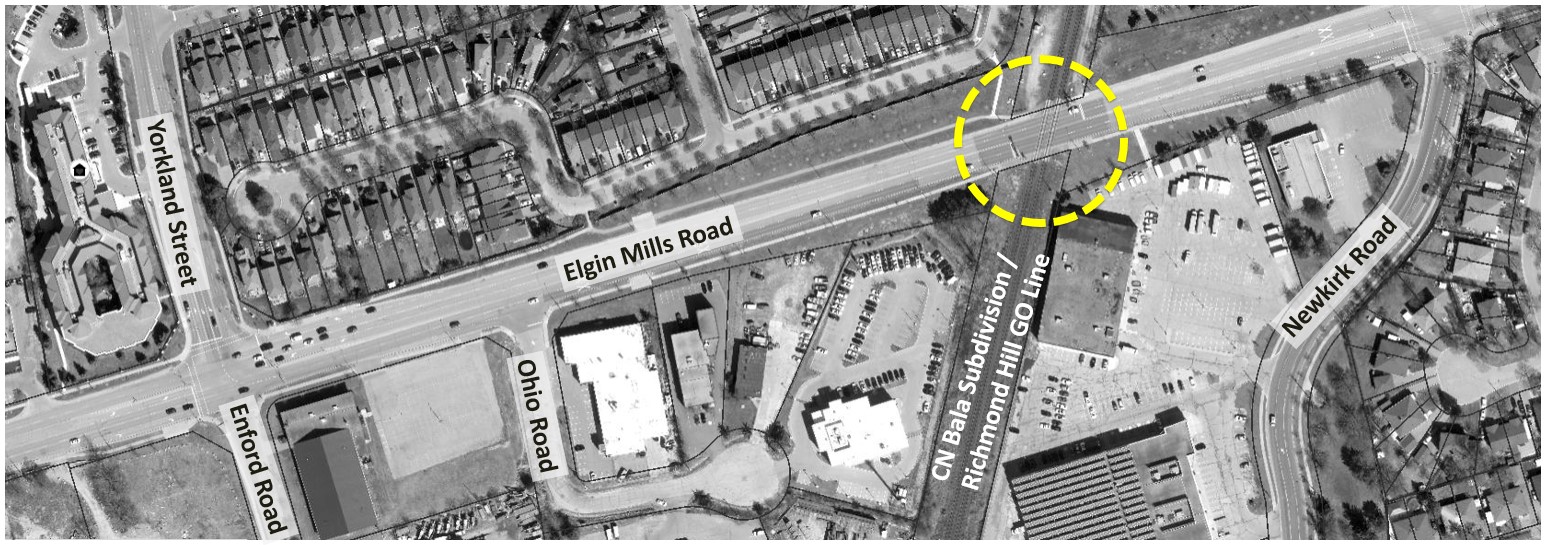
Image Source: Yorkmaps.ca
To determine how to best separate Elgin Mills Road from the level rail crossing and accommodate pedestrians and cyclists the project team will develop the following design alternatives in the next phase of the study. The evaluations and recommendations will be presented at Open House #2.
Alternative 1 – Maintain At-Grade Crossing
Elgin Mills Road crosses the CN rail tracks at the existing level crossing
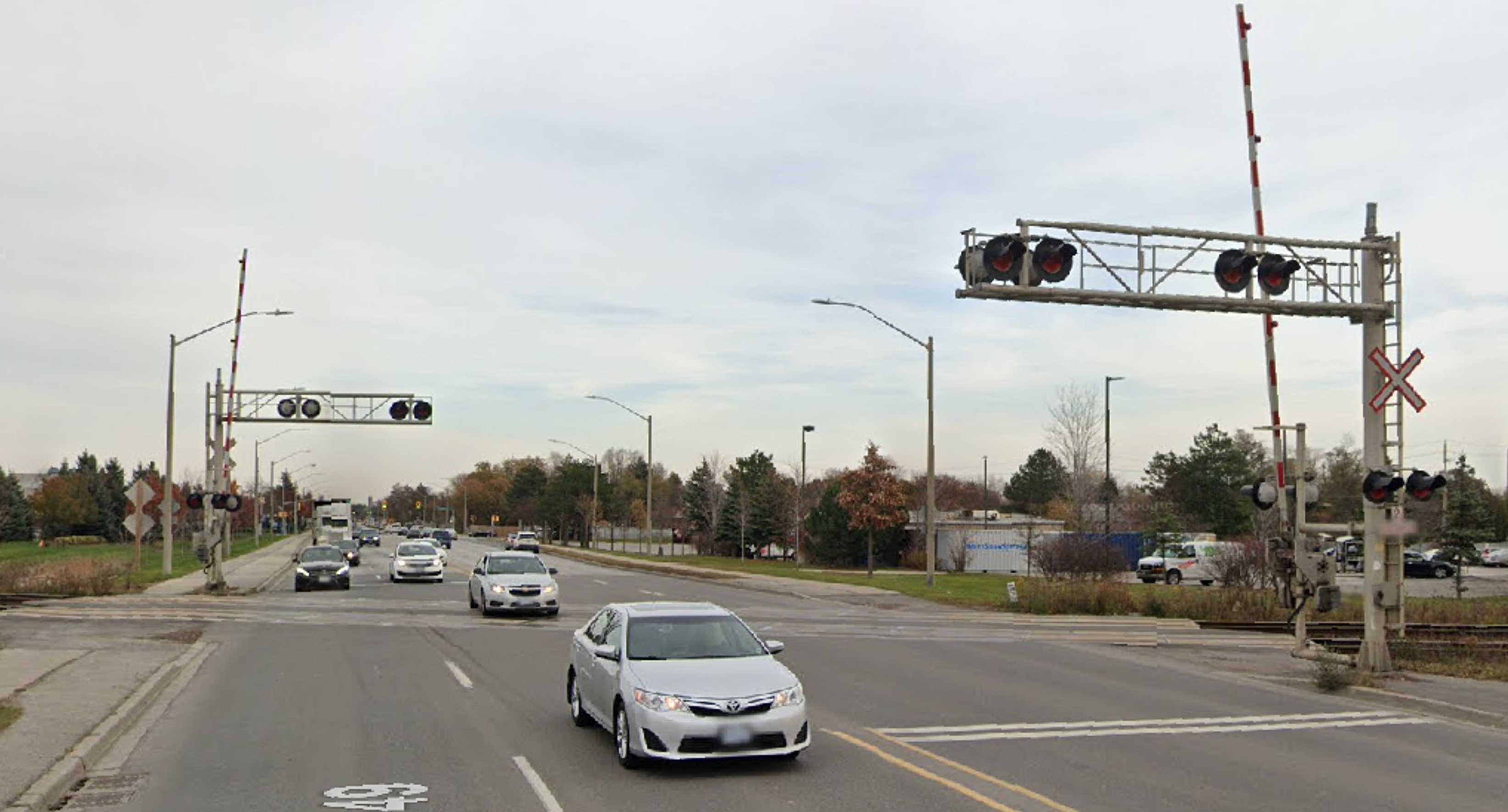
Existing Elgin Mills Road at-grade crossing East of Yonge Street
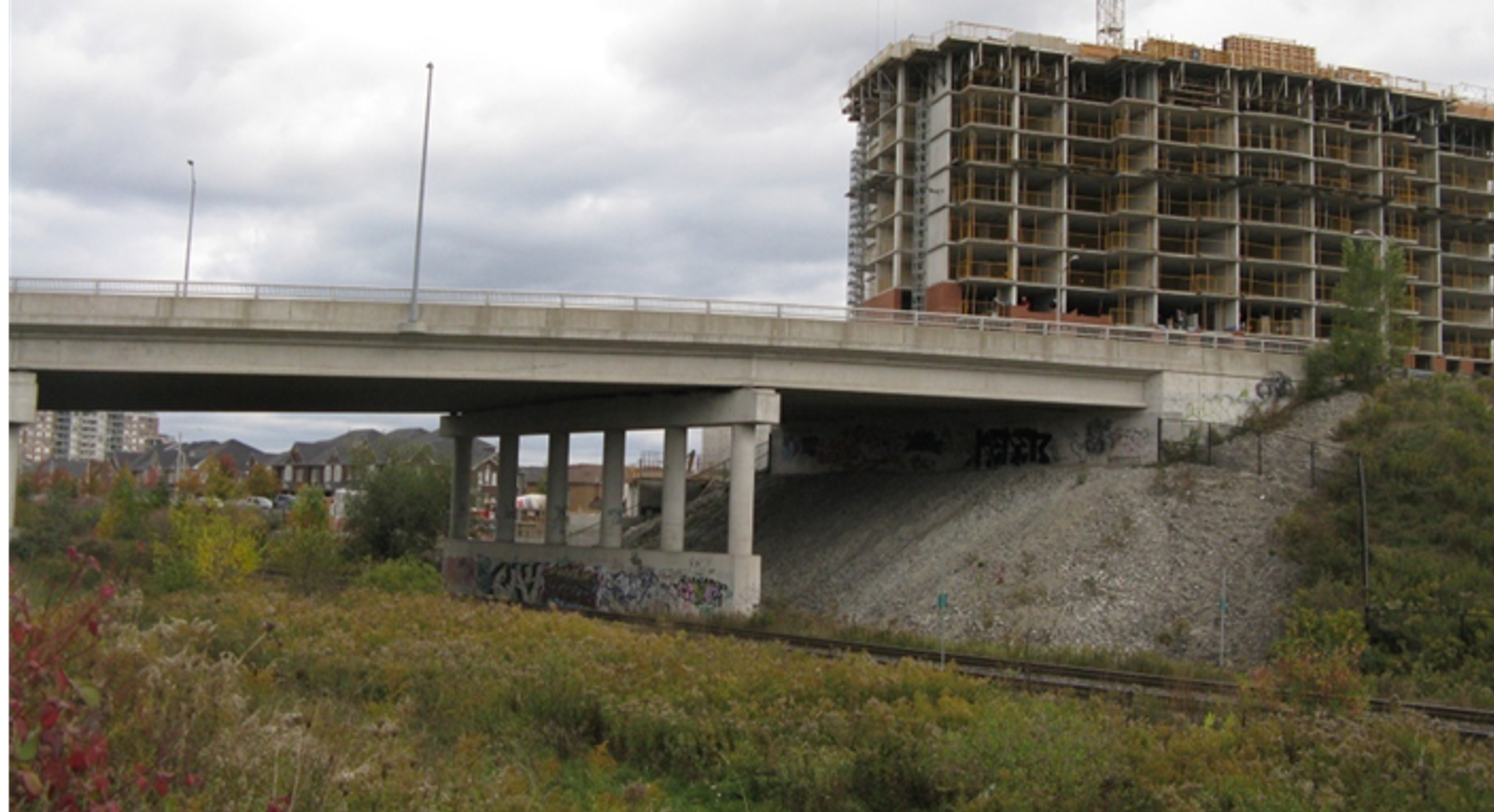
Alternative 2 – Underpass
Elgin Mills Road is lowered under the CN rail tracks

Underpass exampleMajor Mackenzie Drive east of Keele Street
Alternative 3 – Overpass
Elgin Mills Road is raised above the CN rail tracks
Overpass exampleBantry Road east of Yonge Street
Some key considerations the project team will study when developing and evaluating the design alternatives for the grade separation include:
- Distance to Newkirk Road signalized intersection
- Distance to Ohio Road unsignalized intersection
- Proximity between rail crossing and residential homes and businesses
- Existing pedestrian connections to the north and south
- High Groundwater
- Existing Floodplain
- Pedestrian and Cyclist Conditions
- Utilities
- Life Cycle Costs
Give us your feeback!
What’s Next? Active Transportation
What’s Next?
Alternative Design Concepts - Active
Transportation
Along Elgin Mills Road sidewalks are currently provided on north and south boulevards and there are no cycling facilities. To determine how to best accommodate pedestrians and cyclists along Elgin Mills Road between Yonge Street and East of Newkirk Road the following design alternatives will be developed and studied in the next phase of the study. The evaluations and recommendations will be presented at Open House #2.
Alternative 1
- Sidewalk on one side
- Multi-use Path (MUP) on other side, shared space for pedestrians and cyclists to travel in both directions
- Opportunities for boulevard landscaping


Sidewalk
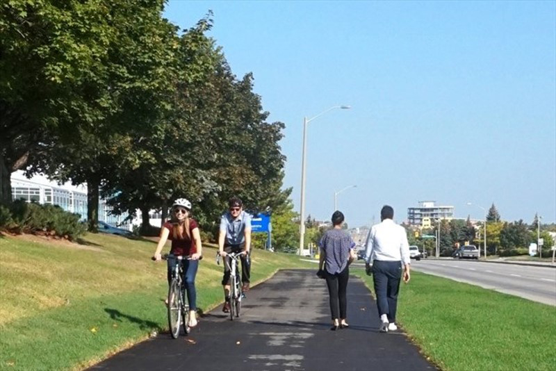
Multi-Use Path
Alternative 2
- Sidewalk on both sides
- Separated Boulevard Cycle Tracks on both sides, cyclists travel in same direction as vehicle traffic
- Opportunities for boulevard landscaping
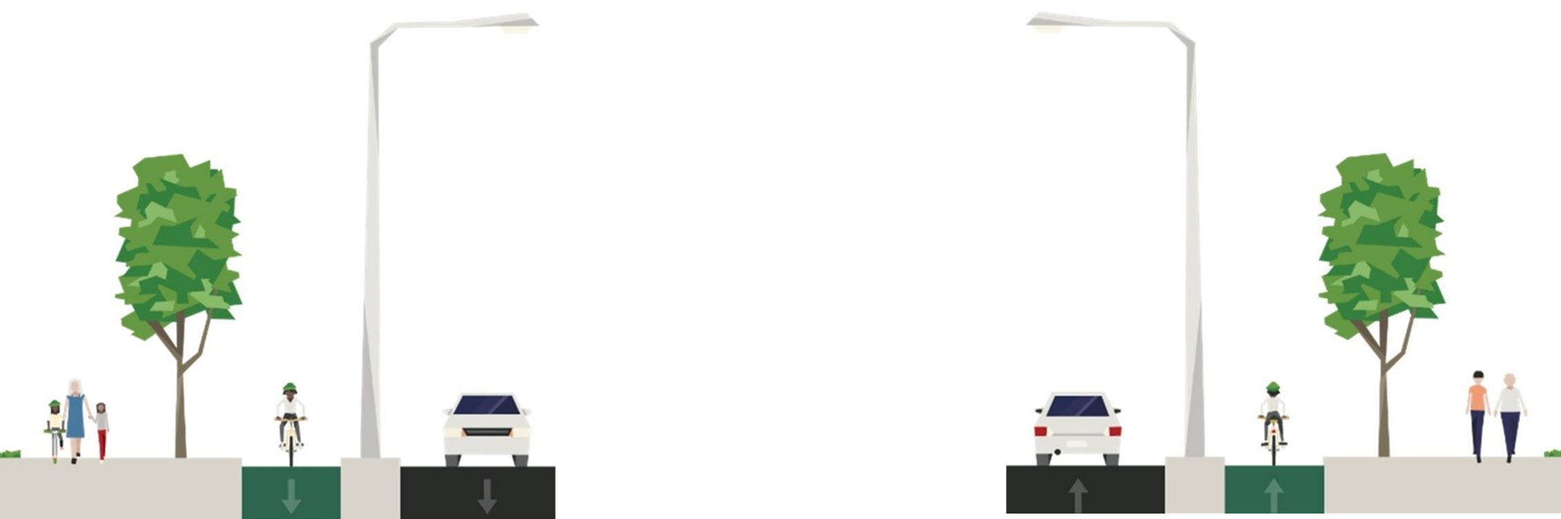
Boulevard Cycle Track and Sidewalk
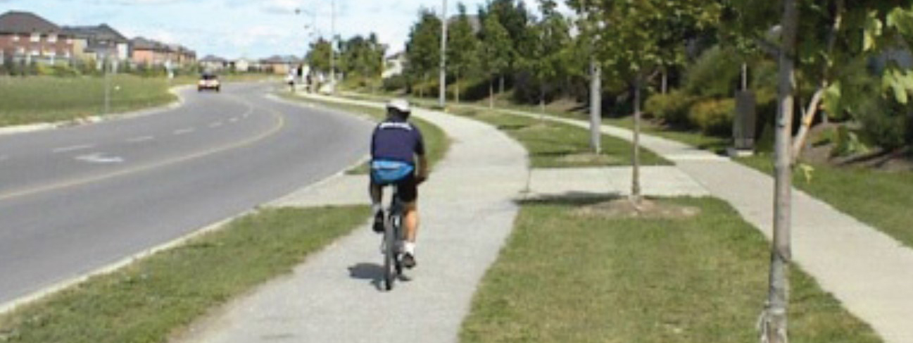
Alternative 3
- Multi-use Paths (MUP) on both sides, shared space for pedestrians and cyclists to travel in both directions
- Opportunities for boulevard landscaping

Multi-Use Path
Give us your feeback!
What’s Next?
Key Technical Studies
The following technical studies will inform the development of the design alternatives, evaluations and impact assessment of the proposed improvements:
Transportation & Traffic Assessment
Noise Impact Assessment

Streetscape and Landscaping
Natural Heritage

Stormwater Management and Drainage

Structural Design

Arborist / Tree Inventory
Geotechnical Investigations

Sub-surface Utilities Investigations

Archaeological Assessment

Hydrogeological Investigations

Cultural and Built Heritage Assessment

Contamination Overview Study

What’s Next?
Evaluation Criteria
Evaluation Criteria
The following criteria will be used to assess the design alternatives in the next phase of the study:
Transportation Service
- Reduce Traffic Congestion and Delays
- Create a Pedestrian-Friendly Environment
- Create a Cyclist-Friendly Environment
- Improve Public Transit Service
- Improve Safety at the Rail Crossing
- Improve Safety for all Travel Modes
- Improve Mode Choice
- Accommodate Emergency Services
Social Environment
- Minimize Impacts to Residential, Institutional and Recreational Dwellings / Properties
- Improve Access to Residential Areas, Institutional and Recreational Facilities
- Mitigate Traffic on Local Streets
- Minimize Traffic Noise
- Preserve Archaeological and Cultural Heritage Features
- Improve Visual Aesthetics
- Improve Community Character
Natural Environment

- Protect Designated Natural Areas
- Protect Vegetation
- Protect Wildlife
- Protect Aquatic Habitat
- Improve Air Quality
- Protect Surface Water and Ground Water
- Minimize Effects on Climate Change
- Minimize Flooding and Erosion and Protect Slope Stability
Infrastructure Design & Economic Environment

- Minimize Utility Relocation
- Accommodate Planned Development and Growth
- Minimize Impacts and Improve Access to Businesses and Key Employment Areas
- Minimize Property Requirements
- Life Cycle Cost (Maximize Construction Value, Minimize Operating Costs)
- Minimize Disruption due to Construction
- Minimize Constructability Complexity
Give us your feeback!
Project Timeline and Next Steps
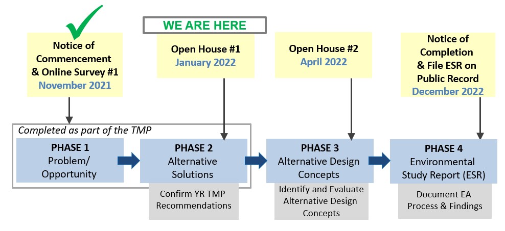
Next Steps
Review feedback from the public and stakeholders.

Develop and Evaluate Alternative Design Concepts. Identify Preferred Design.
Present the Preferred Design at Open House #2. (April 2022)

Timing of Improvements
Timing of Improvements for Elgin Mills Road is identified in the Region’s 2022 10-Year Roads and Transit Capital Construction Program and is subjected to annual review
Recommended improvements:
Construction to commence in 2026
Contact Us
Your input is very valuable to us!
Please provide any additional comments on the Elgin Mills Rd / CN Railway Crossing EA study by entering them below, or contact us by email or phone by February 17, 2022.
Jackson Marin, P.Eng.
Senior Project Manager
York Region Transportation Services

1-877-464-9675 ext.75131
TTY: 1-866-512-6228

Give us your feeback!
Thank you for participating!
For more information visit us at: york.ca/ElginMillsStudy
The frequency and duration of trains passing (especially freight trains) are extensive and result in significant delays for all users